ILS approach tutorial
Don't wanna read all this, check out the ILS approach tutorial video
What is an ILS?
It stands for Instrument Landing System and is a precision approach. It can guide pilots right down to the runway, even in zero visibility. In many cases, there are also high-intensity lighting arrays installed to enable a safe landing. An ILS consists of two independent sub-systems, one providing lateral guidance (localizer), the other vertical guidance (glideslope) to aircraft approaching a runway. When the NAV1 radio is tuned to a localizer frequency, a second receiver, the glide-slope receiver, is automatically tuned to its proper frequency.
How to use it in FS
In FS2004 and FSX, the localizer frequency (also called ILS frequency) can be found on the map. For the map, press the ALT key once so that the top menu appears, then choose 'World' and click on 'Map'. Now the map of your present location will be displayed. For the frequency, click on the green feather of the runway. If there is no green feather, there is either no ILS at that airport or the feather display is off. To check if it is enabled, make sure that the symbol is green. Click on it once if the symbol is red.
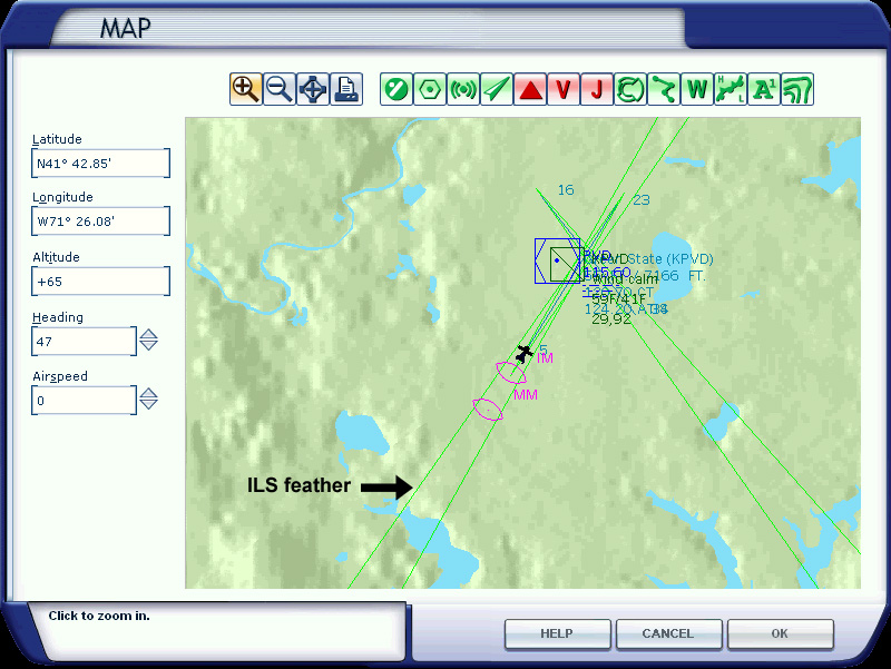
The screenshot above shows you the map of Green State Airport (KPVD) in FSX. The map in FS2004 is very similar. Double click on the green feather to see the facility information.
Now you have the information you need, the ILS frequency and the heading. The heading is usually called 'course' or 'true heading'. Both the frequency and course need to be set in the aircraft instruments, as you can see on the image above.
The ILS frequency must be set in NAV1, by using the knob below the standby frequency. After that, you have to click the switch in the middle in order to make it the active frequency.
When you're flying an IFR flightplan, the build in ATC of fs usually tells you which runway you can expect for the ILS approach, so then you can look up the ILS info and configure the instruments. When you get the ILS approach clearance, then you need to activate the NAV1 radio by pressing the NAV1 button so it lights up. After you have activated the NAV1 radio, you will hear the morse code beeps of the localizer. Together with the ILS approach clearance, you'll get the last heading instruction from the ATC. When your aircraft has turned and is flying the instructed heading, you have to press the APR button (Cessna 172) or LOC button (Boeing 737-800), that is, assuming you're flying by using the autopilot. As soon as the localizer beam has been captured, the aircraft will start to turn and line up with the runway heading and the heading mode is turned off.
On the right, you see an image of the Cessna 172 glideslope/localizer indicator (top) and the PFD of the Boeing 737-800 (footer) in FSX. Both instruments provide lateral and vertical guidance, the one in the Cessna with a real needle and on the PFD (Primary Flight Display) of the 737 with computer generated dots.
If you don't use the autopilot, you have to manually position the aircraft by using the information on these instruments. Before that, you have to wait and see if the localizer is 'alive'. When the vertical needle (or horizontal dot) starts to move towards the middle, the localizer is alive. Then you have to bank (to the right in this case) and keep the vertical needle (or horizontal dot) in the middle. So, if the needle or dot is to the right, you have to turn to the right, if the needle or dot is to the left, you have to turn to the left. When the horizontal needle (or vertical dot) starts to move towards the middle, the glideslope is 'alive'. When it is in the middle, you have to decent while you keep it in the middle. In case you fly by using the autopilot, the aircraft will do all these things for you and align itself with the runway heading when you've pressed the APR or LOC button. In a Boeing 737-800, you need to press the APR button once you see the glidescope coming alive (= when it starts to move towards the middle), although you can already press it when the aircraft has been aligned with the runway heading. In a Cessna 172, there is only an APR button which is both a LOC and APR function.
Autoland
Note that an ILS approach is not an autoland. An autoland system makes use of an ILS, but there is more to it. It requires at least 2 autopilots and often 3 autopilots. None of the default aircraft in FS2004 and FSX are able to autoland. For that, you will need add-on aircraft. Also, the airport must be equipped with an ILS installation (Category III) which makes it possible to autoland. For example, the Boeing 747-400 autoland is called "land3" and makes use of all three autopilots. The aircraft flares and keeps on tracking the runway during rollout. Only the trust reversers must be engaged by the pilot. Check the aircraft reviews section and look for aircraft capable of autoland.
LDA Approach
What if the green feather is not aligned with the runway? Well, on some locations a full ILS approach is not possible due to mountains or other objects that are in the glide path. These are usually called Localizer Type Directional Aid (LDA) and are of a comparable accuracy as a localizer, except that LDA is not aligned with the runway. It provides course guidance down to a point from which you can proceed to the airport by visual references. This type of approach is not very common, but there are still quite a few airports using LDA, most of them middle and small airports.
Juneau Intl (PAJN) in Alaska is a good example. Mountains in the glide path make it impossible to approach straight in.
IGS approach
Another variant on the ILS theme is the IGS approach. IGS stands for Instrument Guidance System and is a modified ILS to accommodate a non-straight approach. The IGS system was used at the old Hong Kong airport Kai Tak (VHHX) for runway 13. A mountain made it impossible to approach straight in, so the pilot had to approach at an angle and upon reaching a small hill marked with a checkerboard in red and white, the pilot needed to make a 47° visual right turn to line up with the runway. Kai Tak was closed in 1998 and replaced by a new airport named 'Chek Lap Kok'.
In both FS2004 and FSX, Kai Tak is no longer an active airport. However, there are scenery packages available that transform Kai Tak in an active and alive airport. Freeware scenery for Kai Tak (FS2004) is available in the AVSIM Library: 9Dragons - Kai Tak Airport
There is also Kai Tak scenery available for FSX: Active ILS, VHHX (Hong Kong Kai Tak Airport)
FlyTampa also made a detailed representation of the Kai Tak airport, for FS2004 and FSX. (PAYWARE): FlyTampa website
Chart of the old IGS approach for runway 13 at Kai Tak (VHHX).

Sion airport (LSGS) in Switzerland is still using a IGS approach for runway 25.
Some airports in fs have a green feather, but no ILS. These airports are equipped with only a localizer and do not provide vertical guidance (glideslope).
Check out the tutorial video section for ILS approach tutorial videos.